Currents Long-Form Stories

Captains of Sea & Industry: Falmouth’s Sense of Place

Written by Laura M. Reckford

FALMOUTH – All that remains of the Old Stone Dock, once the town’s center of commerce, are two rows of boulders that form jetties at Surf Drive Beach. But memories of the dock and the town’s early years have been passed down through the generations and are celebrated by one of the town’s most active neighborhood associations.

Kevin M. Doyle is proud to say that the Old Stone Dock Association, of which he is president, has more members than any other similar association in the town of Falmouth. And that is no surprise to him.

Barbara Weyand and Kevin Doyle take a break at Coffee Obsession with the Falmouth Preservation Alliance's new Heritage Map of Falmouth Village.

Barbara Weyand and Kevin Doyle take a break at Coffee Obsession with the Falmouth Preservation Alliance’s new Heritage Map of Falmouth Village.

“This was the original settlement,” he said of the area in and around Main Street, Shore Street, Surf Drive, Mill Road and Locust Street.

Doyle likes to point out that not all the 250 households that are members in the association even live in the area.

“They come from all over town—anyone interested in preserving what we have,” Doyle said. Concern about preservation of the town’s history and historic buildings has invigorated residents throughout town, even leading to the formation in recent years of an active group, the Falmouth Preservation Alliance.

Barbara Weyand, the president and a founding member of the Alliance, said, the center of town where the Old Stone Dock Association is located is bigger than the borders of certain streets downtown. “It’s a state of mind. There’s a strong sense of identity around the value of the area,” she said.

Local preservationists are focusing on a restoration of Falmouth's crumbling bus depot, which originally served as a train depot.

With an advisory committee that includes members of the Falmouth Preservation Alliance and Historic Districts Commission, the Falmouth Economic Development and Industrial Corporation (EDIC) is restoring the former train station, now the bus depot, to its original appearance of the 1913 building.

The preservation spirit has taken hold in Falmouth and leaders in the movement are seeking to preserve what is left of the town’s historic identity. A major project to restore the old train station on Depot Avenue is front and center for the group now but so is an intense focus on the town’s historic core.

Weyand, one of the early organizers of the Alliance, downplays her role. “I’m just the group nag,” she said. But her enthusiasm for the town’s history is palpable. In a recent tour of historic sites in the center of town with Doyle and Weyand, the two riffed on 300 years of people, places and things that make Falmouth unique.

Both Weyand and Doyle credit property owners in the center of town with maintaining the historic character that has kept the area unique through booms and busts over the decades.

“We haven’t been McMansioned in this part of town the way the other villages have suffered,” Weyand said.

Members of the Alliance believe that preservation of that historic character in Falmouth has been and remains a big part of the economic development of the town, what attracts tourists, as well as businesses to town, Weyand said.


WaveA Town’s History Demolished

The Falmouth Preservation Alliance sprang up in 2014 after several of the town’s historic buildings were torn down.

Falmouth's Village Green can serve as a starting point for a tour of the town's historic sense of place.

Falmouth’s Village Green can serve as a starting point for a tour of the town’s historic sense of place.

“It was like dominoes for awhile. We were just losing building after building,” Weyand said.

One house, the Zylinski property on Teaticket Highway, was replaced by a national chain tire store whose uninspiring boxy architecture and giant neon sign served as a rallying cry for locals like architect Jill Neubauer who has expressed concern that similar blights could spoil other parts of town.

Weyand and other civic-minded Falmouth residents decided more attention needed to be paid to the town’s historic treasures before they were all lost. The group is working with local artist Karen Rinaldo on a series of maps highlighting the town’s historic structures. The first one, the Heritage Map of Falmouth Village, is complete. The second one, a map of Woods Hole and Quissett is in the works. (To find out where to get a copy of the map, click here.)


WaveIt Began With The Nimrod

It was back in 2013, when it looked as though the more than 200-year-old building housing the Nimrod restaurant would be demolished, that a number of residents began a lively conversation about preserving the town’s history. (Read a story about the planned demolition of the Nimrod here.)

The Old Stone Dock, now just an arch of boulders at Surf Drive Beach, once served as the commercial center of town.

The Old Stone Dock, now just an arch of boulders at Surf Drive Beach, once served as the commercial center of town.

The Alliance was started about one year later in an effort to unite longtime residents and preservationists with town leaders in the civic and business spheres. One of the first projects of the Alliance is the Heritage Map, which covers the center of Falmouth Village, including the Old Stone Dock area.

Using the Old Stone Dock as a basis for understanding Falmouth’s early history is no stretch. The dock that gave the association its name may no longer exist. But back in the early years of the town’s founding, the dock was the center of commerce and the epicenter of the town’s growth.

In a one-hour driving tour of downtown, Doyle and Weyand pointed out the parts of Falmouth that give it a unique sense of place. This tour can be taken as a self-guided stroll using the alliance’s first heritage map as a guide.


WaveFalmouth’s Village Green

When you talk about a sense of place in Falmouth, the best place to start, according to Doyle and Weyand, is on the Village Green, which was laid out in 1749 as a place for a meeting house and a training ground for the local militia.

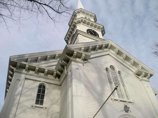
The First Congregational Church on the Village Green was the third meeting house built in town.

The First Congregational Church on the Village Green was the third meeting house built in town.

Alongside the green are the First Congregational Church, built in 1857 as the town’s third meeting house. The church’s bell was crafted by famed silversmith and patriot Paul Revere in 1796.

The other church on the green, St. Barnabas Memorial Church, a handsome 1890 red stone church that houses an episcopal congregation, is on land fronting Siders Pond. The land and funds to build the church were donated by the Beebes, a family that was among the town’s philanthropic patrons after they came to town in the 1870s.

Also notable on the green is the 1730 Conant House and the 1790 Dr. Francis Wicks House, part of the Falmouth Museums on the Green, the campus of structures run by the Falmouth Historical Society.

The Conant House is the oldest house on the Village Green but there are others that date to the 1700s.

Just west of the green is the 1810 home where the poet Katharine Lee Bates, author of “America the Beautiful” grew up.

Also fronting the Village Green is a handsome columned 1821 building now housing Bank of America. This was originally the location of Falmouth National Bank, which was key to the town’s early commercial success.


WaveMain Street’s Sense of Place

Continuing east on Main Street to the commercial center of town, there is the Eastman’s Block, built in 1924 and still housing the original hardware store that gave the block its name, and, further on, the Week’s block, built in 1922. These are among the commercial buildings in the center of town that Weyand said are “instrumental in maintaining the character of the town.”

Falmouth Museums on the Green includes two historic homes, as well as a barn with historic displays.

Falmouth Museums on the Green includes two historic homes, as well as a barn with historic displays.

The importance of maintaining a hardware store on the main street of a town cannot be underestimated, according to experts in historic preservation. The demolition of Teaticket Hardware, in the neighboring village of Teaticket, which went out of business soon after the opening of the nearby Wal-Mart, was thought by some to be the death knell of community character of that village center. The center of Teaticket is now most notable for the looming afore-mentioned tire store. The demolition of the hardware store was eulogized in the poem “Death of Teaticket Hardware” by Alice Kociemba.

Back to the center of Main Street, behind town hall is Siders Pond, named after Consider Hatch, one of the early settlers of Falmouth, Weyand said.

Across Main Street is the masonic hall, one of the oldest in the country. Parts of the building date to 1799 when it was used as a schoolhouse.

The historic Weeks Block houses a restaurant and stores on Main Street.

The historic Weeks Block houses a restaurant and stores on Main Street.

The stately columned Greek revival Lawrence Academy building, built in 1842, the town’s former high school, now houses the Falmouth Chamber of Commerce. A project is underway to preserve the cupola.

Around the turn of the 20th century as the town of Falmouth became a tourist town, Main Street shifted from mostly homes to commercial buildings and the vestiges of the architecture of the homes can still be seen in the second floor residential rooflines along the street, according to Weyand.


WaveThree Cannonball Holes

The Elm Arch Inn, located on tiny Elm Arch Way off Main Street, is one of three remaining buildings in town that have cannonball holes from a battle off Falmouth during the War of 1812. The building that houses the inn was moved from its previous site on Main Street where it was struck by the cannonball, Weyand said.

The Elm Arch Inn, which has a cannonball hole left over from the War of 1812, was in danger of demolition.

The Elm Arch Inn, which has a cannonball hole left over from the War of 1812, was in danger of demolition.

There were more than 30 buildings that were hit by cannon fire during the battle but only three buildings remain. Besides the Elm Arch, there is the Captain Silas Bourne House on the Shoreway Acres property and the now-vacant Nimrod restaurant building on Dillingham Avenue. The cannonballs are all gone, perhaps taken long ago by souvenir hunters—and only the holes remain, Weyand said. Both the Nimrod and the Elm Arch have been threatened with demolition in recent years.

Falmouth Public Library, built in 1901, occupies a central spot on Main Street. The library was expanded in the mid-1960s and again in 1978 and in 2008. On the library lawn facing Main Street is the statue of Falmouth’s famed poet Katharine Lee Bates, and Memorial Lane, a tribute to the town’s veterans going back to World War I.

On the sidewalk in front of the library lawn are a series of bronze plaques by local sculptor Sarah Peters illustrating the town’s commercial history. This is also a popular spot for the town’s flock of turkeys to congregate, often stopping traffic in the summer as they meander across the busiest section of Main Street. (For stories and videos about Falmouth’s turkeys, click here.)


WaveShore Street To The Beach

At the corner of Shore Street and Main Street, the former Falmouth Hotel building, built in 1872, now houses a hospice agency and serves as housing for summer hospitality workers.

The Counting House is one of the historic homes on Shore Street.

The Counting House is one of the historic homes on Shore Street.

Doyle explained that Shore Street was cut through, “straight as an arrow,” from Main Street to the beach around 1800, as the direct route from the village to the Stone Dock.

Among the historic structures on Shore Street is the old Counting House, left over from the town’s years in the shipbuilding industry. It was built to maintain accounts for sea captains and merchants.

One of the oldest homes on Shore Street is distinguished by its red door.

One of the oldest homes on Shore Street is distinguished by its red door.

Also along Shore Street are three homes that were owned by the Beebe family as part of a 100-acre farm property they had in the area. The farm was broken up for development in 1932.

The Beebes, a Boston family, made their fortune in dry goods, their stores eventually becoming Jordan Marsh. They came to Falmouth at the invitation of their friend, the industrial magnate James Story Fay, Weyand said. The Beebes also owned the 1,000-acre Beebe Woods and Highfield Hall mansion properties in Falmouth.

Barbara Weyand and Kevin Doyle show the new Falmouth heritage map to Don Filliault of the Beach Breeze Inn.

Barbara Weyand and Kevin Doyle show the new Falmouth heritage map to Don Filiault of the Beach Breeze Inn.

The Beebes and Fay are just a couple of the captains of industry who were early visitors to Falmouth. These prominent families and the train that brought them to town, beginning in 1872, attracted other wealthy people to build summer residences in town.

The 1879 Beebe mansion known as Tanglewood was demolished in 1977 and concerns about the impending demolition of the other Beebe mansion, Highfield Hall, resulted in a grassroots fundraising effort and a multi-million renovation of Highfield Hall. It now serves as a historic home museum, art center and function site.

Near the beach end of Shore Street where it turns into Surf Drive, there is the Beach Breeze Inn, which is built around the 1858 house of Colonel Charles F. Morse, a Civil War officer. Owners Don and Joyce Filiault have owned the property for 14 years and loving restored it. At first skeptical of the value of restoring the old home instead of demolishing it, Don Filiault said in the process of restoring the house, he became a believer. “It’s all about the bones” of the old home, he said, sounding just like the preservationist he has become.


WaveThe Old Stone Dock

At the foot of Shore Street is the remains of the Old Stone Dock, which was the center of commerce for the town more than 200 years ago.

An octagon house on Thomas Drive once served as a base for a windmill.

An octagon house on Thomas Drive once served as a base for a windmill.

The dock was first built in 1806 when the shoreline was lined with windmills powering saltworks from Falmouth Heights all the way to Woods Hole. The last remaining windmill, now an octagon house on Thomas Lane, can be seen by looking back at Shore Street from the beach parking lot.

Before refrigeration, salt was a critical product and the industry was an important one on the Cape. In 1845, Falmouth had 42 saltworks operations along the shore.

Doyle said a wooden pipe left over from the old salt works can still be seen along Surf Drive. Bill Swift, whose family was in the saltworks business, gave a presentation about the industry and surprised those gathered by drawing their attention to the old pipes, at a recent Old Stone Dock Association meeting, Doyle said.

According to Doyle, history abounds in the area near the Old Stone Dock.

Preservationists call this boulder "Falmouth Rock," because it names the original "proprietors" who settled the town.

Preservationists jokingly call this boulder “Falmouth Rock,” because it names the original “proprietors” who settled the town.

“This is where the town began, right here,” Doyle said.

But English founders of the town were not the first inhabitants of the area. Evidence that Native Americans used to visit the area includes the numerous arrowheads and Indian pottery discovered nearby.

The town’s main industries 200 years ago were shipbuilding and whaling.

After the Great Gale of 1815 destroyed the dock, it was rebuilt in 1817. The stones still in the water are all that is left of the old dock.

Near the parking lot just up the beach from the boulders is a plaque marking the site of the original Old Stone Dock.

Fresh River links Siders Pond to Vineyard Sound at Surf Drive Beach.

Fresh River links Siders Pond to Vineyard Sound at Surf Drive Beach.

The center of the town’s maritime commerce shifted with concern about boats not having enough protection from storms. Town leaders decided to turn a nearby salt pond named Deacon’s Pond, into a new sheltered harbor. So in 1904 Deacons Pond became Falmouth Harbor and Clinton Avenue was cut in half by the dredging that took place to turn the pond into a deep water harbor.

Storms continued to affect the town throughout the 20th century. The Ellen T. Mitchell Bath House is on the site of what was a two-story “bathing casino” that was destroyed by the Hurricane of 1938. The pilings that can still be seen in the water are what is left of a long fishing pier from the era.

A boulder further west on Surf Drive opposite Mill Road holds what is perhaps an even more important plaque.

“It’s our Plymouth Rock,” Doyle said.

A close of of the inscription on Falmouth Rock.

A close up of the inscription on Falmouth Rock.

“Falmouth Rock,” a name Doyle said was jokingly coined by Falmouth resident and former innkeeper Jim Lloyd, lists the original “proprietors” who were the first settlers of Suckanesset, the name given by settlers to the area in 1602. The town was renamed “Falmouth” in 1686. The names on the plaque, Hamlin, Hinckley and Robinson, among others, can be found on roads around the center of town.

Mill Road, just across Surf Drive from the plaque, was one of the first roads in Falmouth and was originally a Native American trail, according to Doyle.

Weyand explained that with the arrival of the train that brought tourists to town in the late 1800s—attributed to James Story Fay who needed a way to get from Boston to his Falmouth properties, “it flipped the switch from an agrarian fishing town to all this grandeur. It changed the character of the town.”


WaveSurf Drive Changes

Doyle pointed out that the neighborhood adjacent to the beach changed substantially in the 20th century with estates broken up into housing developments.

Kevin Doyle shows a view of Salt Pond from the deck of his home on Mill Road.

Kevin Doyle shows a view of Salt Pond from the deck of his home on Mill Road.

One neighborhood adjacent to the beach, Bywater Court, is named after George Bywater Cluett, shirt manufacturing heir. He purchased the land from Garret Schenck, founder of the Great Northern Paper Company, who had an estate in the area. The Bywater community, designed by local architect E. Gunnar Peterson, in a sleek 50s modern style affordable for returning veterans from World War II.

Many of the houses now serve as summer beach retreats. As they have been expanded and remodeled, some have been raised up because of the danger of flooding and no longer resemble the modern aesthetic that they were built with originally.

Fresh River, the water body that connects Siders Pond to Vineyard Sound at Surf Drive Beach, used to be an active herring run, Doyle said, but with the building of Surf Drive, the flow has been severely impeded. Doyle would like the herring run to be restored.

A small island in Salt Pond was built for the owner of an estate near by.

A small island in Salt Pond was dubbed “Mrs. Dwight’s Island. It was built for the owner of an estate near by.

“When a kid came down with a net, you’d get minnows by the bucket. Now you can’t find anything,” he said.

The Old Stone Dock Association maintains the parking lot at the corner of Mill Road and Surf Drive. The lot was the location of a grand mansion known as the John E. Dwight House. Dwight, president of Arm & Hammer Company, built the house in 1884. It was destroyed in the Hurricane of 1938.

All that remains of the Dwight estate is the carriage house, the pale yellow house beside Mill Pond. Notable for the archways facing Mill Road, it was originally built to stable horses and carriages. Just off shore of the house is a tiny island in Mill Pond still known as “Mrs. Dwight’s Island.” It was built for her quiet enjoyment, Doyle said.

A circa 1888 stone wall fronting Surf Drive and continuing up Mill Road defined the edge of the Dwight property. Doyle, who owns a home nearby takes pride in maintaining it.

The small stone wall that many likely pass by without even noticing was partly buried and grassed over until Doyle and others sought to restore it.

“This is a treasure. I don’t think may people realize this is where Falmouth began,” Doyle said.

The wall protrudes toward the street every 10 feet. “Someone put some thought into that,” Doyle said.


WaveMill Road: One of Falmouth’s Earliest Routes

Another notable property nearby on Mill Road was owned by the Honorable Richard Olney, Secretary of State under President Grover Cleveland. His grand 1890 home was also destroyed in the Hurricane of 1938. The property has been subdivided into about 10 houses on a street named after him.

The carriage house is all that remains of the Dwight estate at the corner of Surf Drive and Mill Road.

The carriage house is all that remains of the Dwight estate at the corner of Surf Drive and Mill Road.

Further up Mill Road on the corner of Salt Pond Road was the site of the original windmill that gave the streets its name. It was later a place where summer classes were held by Miss Mary P. Windsor in 1887. The windmill was dismantled in the 1930s.

Also along Mill Road there is a prominent stone wall fronting Salt Pond Place, this one made of Falmouth pink granite. The property was originally a farm built by Nathaniel H. Emmons in the 1880s.

“The wall is such a key character to the town and the approach from the back [side of the town],” said Weyand.

The Old Burying Ground off Mill Road contains the graves of the first European settlers of the town.

The Old Burying Ground off Mill Road contains the graves of the first European settlers of the town.

Tucked in at the Locust Street end of Mill Road is an ancient cemetery called The Old Burying Ground, which dates back to 1688 and is the final resting place for many of the original proprietors who founded the town, including Deacon Moses Hatch, the first Englishman to be born in Falmouth. Visitors to the cemetery can walk to the shore of Siders Pond.

Near the entrance to the cemetery at the end of Mill Road is a triangle of grass in the middle of the road containing the Sailor’s Memorial dedicated in 1907 to the seafarers of Falmouth, a rock affixed with an anchor and a bronze plaque.

Always attentive to the needs of historic sites, Doyle wants to give the anchor a fresh coat of paint and cut back the rhododendrons that have thrived to the extent that they partially block the monument.
Doyle said, purportedly a time capsule is buried under the rock that may have been buried there in 1916, making it 100 years old this year.

A circular route back to the start of the heritage trail passes a row of captain’s houses on Locust Street and takes a detour up Depot Avenue to the bus depot, formerly the train station, built in 1913.


WaveThe Bus Depot

The effort underway by the Falmouth Economic Development and Industrial Corporation (EDIC) to restore the station includes the Falmouth Station Advisory Committee, on which Weyand sits.

A large anchor marks a historic memorial to the town's seafarers.

A large anchor marks a historic memorial to the town’s seafarers.

Weyand said the idea to restore the station gained steam as the property became more and more dilapidated.

“Various constituencies have been interested in its restoration and ashamed of its appearance. People who take the bus, [disembark] and they are dropped into a third world country with cement on the facade literally falling off and a rotting overhang,” she said.

Weyand explained it took years to figure out who actually owned the building (the Department of Transportation) and then to negotiate with them to allow a restoration effort. The DOT is contributing $1.4 million to the restoration, which is being spearheaded by the committee and the EDIC, Weyand said.

Weyand said, restoring the building and the two-acre property it sits on is an opportunity for the town to bolster its tourist economy.

“It was sufficiently embarrassing to a town as affluent and civic-minded as we are that it took this long to percolate to a level where something actually got done,” Weyand said. “It’s a great feel-good project. Who doesn’t want a visitor’s first impression to be good?”

Moving forward, the Alliance is working on a series of maps highlighting historic sites in all of Falmouth’s villages and is looking to reach out to residents about the town’s historic treasures.

“We’re hoping to raise the awareness of people in the villages to look at our historic assets. Collectively they are defining aspects of the town and they contribute to its economic engine,” she said.

About the author

Laura M. Reckford

Laura M. Reckford is co-founder of Cape Cod Wave. She has been a reporter and editor on Cape Cod for more than 20 years in magazines, newspapers and radio. She has also authored numerous Frommer's Travel Guide editions on Cape Cod, Martha's Vineyard and Nantucket.

4 Comments

  • Fantastic writing of some of the history of this great town.Hope there will be more coming about some of villages in Falmouth.

  • This is an extremely well-written, informative overview of the Town of Falmouth. Fascinating history of the town. One “drives by” so many of these places and has no idea as to the history. Kudos to those who are working so hard to keep “old” Falmouth “alive”.

  • Is James Story Fay mentioned in this well written and informative piece the same person as Joseph Story Fay who was an early resident of Woods Hole who brought in Michael Walsh who then produced the wonderful rambler rose? He was also a most generous benefactor to his adopted community.

    • Yes, that’s him. Mr. Fay is also the person who encouraged the Beebe’s to join him as the first seasonal residents in Falmouth. Between them, they set a course for the Lilly’s and other more recent benefactors who have given so much to the town.

      ps Go back and read the link to “The Death of Teaticket Hardware” – it’s what Falmouth has always been about! kmd

Leave a Comment

error: Content is protected !!