Currents Long-Form Stories

Can This Cape Cod Beach Be Saved? Falmouth Fights Coastal Erosion

Menauhant Beach
Written by Brian Tarcy

EAST FALMOUTH – When Bruce Mogardo, 70, now the Falmouth Beach Superintendent, was a boy in the 1950s on Menauhant Beach with a makeshift fishing rod made from a floating house shingle, he said, the beach was 150 feet wider than it is now.


While life for kids and their ubiquitous electronic gadgets on Menauhant Beach is certainly different these days, the beach itself has changed even more dramatically. 

Menauhant Beach

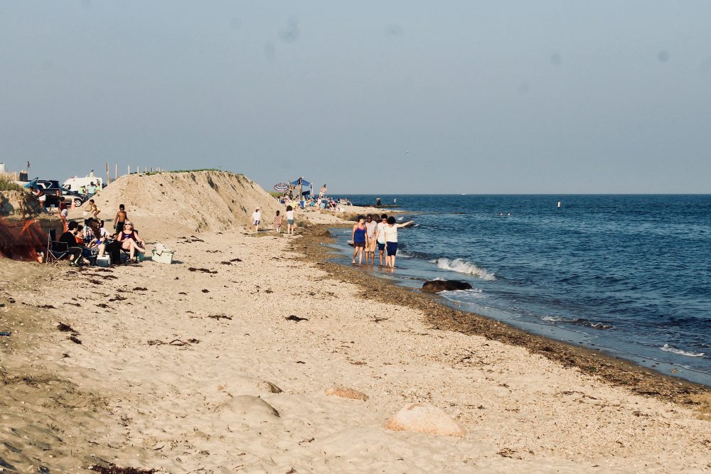
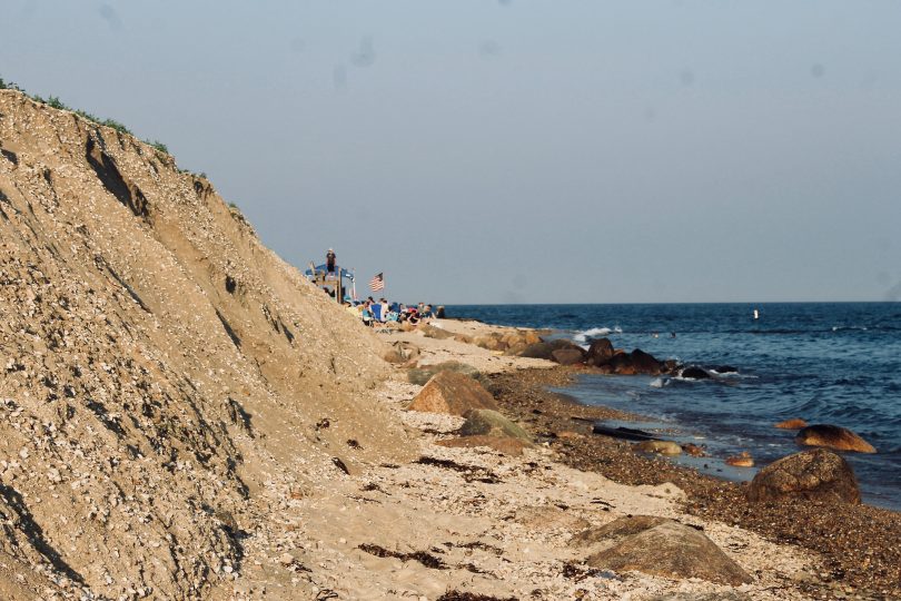
Can humans out-engineer Mother Nature. CAPE COD WAVE PHOTO

Eric Turkington, 70, a former Falmouth selectman and former state representative who was a parking lot attendant at Menauhant Beach in 1966, said, “It’s changed a lot… This particular location has always been a pressure point for coastal erosion.”

In other words, Menauhant Beach is slowly disappearing. “Today, it is probably one-third the size that it was 15 or 20 years ago,” said Raymond Jack, director of the Falmouth Department of Public Works.

The question now is, can humans out-engineer nature?

“In the long term, no,” said John Ramsey, principal coastal engineer with Applied Coastal Research of Mashpee, the firm tasked by the town with designing plans to fortify the beach.

But the plan is to buy 75 years with some coastal engineering, and then re-assess along the way.

If nothing is done, “based on the erosion rate we’re seeing, in 30 to 40 years the shoreline will actually reach Menauhant Road.” – John Ramsey, principal coastal engineer with Applied Coastal Research.

If nothing is done, “based on the erosion rate we’re seeing, in 30 to 40 years the shoreline will actually reach Menauhant Road,” said Ramsey.

“The beach is one thing,” said Jack. “The road is another thing. It’s decision time. Do you protect or retreat? If you retreat, where do you retreat to? Abandonment, not only of the beach, but of the road, that’s not logical.”

Beyond the economic benefit of the beach to the town, and the spectacular views driving along that road, Jack pointed out that is the only connecting point at the coast side of two long peninsulas. Without the road and bridge, there could be all sorts of public safety issues, he said.

Menauhant Beach

Menauhant Beach.

“This is not a new issue,” said Charles T. McCaffrey, chairman of the Falmouth Coastal Resiliency Action Committee. “In the 1951 Falmouth master plan, it was proposed to move the road significantly inland with a much longer bridge crossing the coastal pond rather than going along the barrier beach.”

That 1951 plan remained just that – an unpopular plan no one thought much about since.

And so the town is now engaged in a plan re-fortify the beach while widening the channel into adjacent Bournes Pond, and then install a new bridge over the proposed widened channel. It is a complicated project, attempting to clean the nitrogen from Bournes Pond by improving the flow with the widened channel while at the same time saving the beautiful coastal road and barrier beach.

Erica Szuplat, 41, an artist who grew up going to that beach said Menauhant was once “as nice as any other beach in town… I loved the time I spent there growing up.” But now, she said, “it’s just not a great beach anymore.”


WaveA History Of Changes; Some Were Man-Made 

“Things have changed there. A lot of it is man-made,” said Turkington.

“In the middle of the 1800s, the inlet was where it is now,” said Ramsey. “It naturally migrated to the west. When a wooden bridge was built connecting Central Avenue to Davisville Road, Ramsey said structures were put in place to hold the inlet where it was at the time, at the west end of the beach.

Menauhant Beach

Eric Turkington, of the Falmouth Water Quality Committee.

“In my lifetime, there was a motel on what is now the public beach. Towards the west,” said Turkington. He told a story about two feuding owners, two different fires wiping out first a guest house and then a motel, some suspicious foundations, and even a Massachusetts Supreme Judicial Court ruling before the motel property was eventually sold to the town as part of the public beach.

Part of the foundation for the hotel is still on the beach, near the foundation of the old wooden bridge. “That wooden bridge is still there, just buried under the sand,” said Szuplat.

The parking lot, said Turkington, used to be on the other side of the road. At some point the parking lot was moved because, he said, some in town thought that it was “not safe to have a parking lot on one side of the street and the beach on the other side because all the little kids would be running across the street in traffic.”

Menauhant Beach

Kids playing on the remnants of the old wooden bridge. CAPE COD WAVE PHOTO

“It used to be one long stretch of beach,” recalled Szuplat.

Mogardo recalled “in the 50s and 60s the water flowed underneath the wooden bridge so well, you could dive off of it. It was 70- to 80-feet wide and you could ride a tube all the way out to the ocean. But then the sand began to fill in and the flow decreased. Then a lot of times, the storms would blow it back open.”

“As a lifeguard in the 60s, if it was not great weather, two of us would dig up a half a bushel of clams out of Bournes Pond and give them to the beach superintendent, who then gave them out to a few friends or family,” said Mogrado, who has worked for the beach department for 47 years.

Mogardo laughed when asked if that kind of thing still happens. “I can assure you no one is digging quahogs and giving them to the beach superintendent.”

Menauhant Beach

Bruce Mogardo, Falmouth Beach Superintendent. CAPE COD WAVE PHOTO

In the 1980s, the town’s shellfish warden, George Souza, convinced the town that Bournes Pond and the associated shellfishing would benefit from moving, straightening and widening the channel. This also entailed building a new bridge. All of this was finished in 1985.

The old channel was narrow and winding, and would plug up, said Turkington. At times, he said, “the pond became a stinking swamp.”

“The inlet kept filling in and wasn’t flushing properly,” said Mogardo. “There was not enough water moving. Any time you have a pond that big where the water does not purge, it won’t keep clean enough to keep the shellfish in good shape.”

Menauhant Beach

Bournes Pond, across from Menauhant Beach. CAPE COD WAVE PHOTO

Once the inlet was moved in the mid-1980s, the shellfish thrived, said Mogardo. “Within two years, that pond was booming with shellfish. George [Souza] used to tell me that he had a video of a man, legally blind, digging for clams with his hands and pulling in a half a bushel. There were eels and flounder and crabs. That pond was booming.”

But, said McCaffrey, hindsight says that “the secondary effects were not fully appreciated.”

“What has been happening since that time,” said Jack, is the area “is still adjusting to the change. In the scheme of things, those kind of coastal changes take decades, not just a few years.”

But one secondary effect, said Jack, is “we’re seeing erosion on the western portion of the beach, west of the current bridge.”

Ramsey said there was a shoal that built up over time that had protected the beach. “Once you moved the inlet, the shoal that protected that beach started disappearing.”

Mogardo said the big change began to occur after Hurricane Bob in August, 1991. “I don’t have those fancy degrees others have,” he said of his expertise. “I’m just a local East Falmouth boy with local knowledge.”

Menauhant Beach

The existing bridge at Menauhant Beach was built in 1985. CAPE COD WAVE PHOTO

And Mogardo’s local knowledge recalls there used to be two sandbars between where the old bridge was and the new one, and they operated on what he called “a put and take system. What the ocean took out this month, it would give back the following spring,” he said.

According to Mogardo, during Hurricane Bob, the water rushed into Bournes Pond and was held inside the pond and “the pond level was extremely high.” He said that then “the water came out at such a volume, it took those two sandbars with it. And the rate of erosion increased… the bottom changed and there was a steady rate of erosion starting in 1992 and 1993.”

And while the erosion on the beach accelerated, Bournes Pond became threatened by increased nitrogen levels, prompting calls for sewering.

In this coastal/tourist town where water is lifeblood, committees were formed, town meeting was asked to write a big check and the state has been asked for grant money and permission, and will be asked for more.

The plan is to take on Mother Nature with engineering.


WaveThe Proposed Project

The cost to move the channel and build the new bridge is about $5 million, said Turkington, who is a member of the town Water Quality Committee.  “It’s a relatively inexpensive way of restoring Bournes Pond, which, like other estuaries, is overloaded with nitrogen” he said.

Menauhant Beach

The existing channel into Bournes Pond. CAPE COD WAVE PHOTO

Widening the channel from its current opening of 50 feet to a nearly double width of 90 feet will flush the pond enough to require much less sewering nearby than would otherwise be needed, he said. “Half the nitrogen we have to remove from there will be removed by this one action,” said Turkington.

While the plan to widen the channel and build a new bridge has been in the works for a while, and is in the midst of a state permitting process, Ramsey said the town also realized that the coastal erosion had to be confronted.

If the road leading up to the bridge ends up gone, “it sort of defeats the purpose of the whole project,” said Ramsey.

“It’s a challenging shore protection problem to protect a barrier beach where you have a road along the barrier beach,” said Ramsey. “That’s a fairly common problem on Cape Cod.”

“At this point,” said Jack, “I could at least be cautiously optimistic that we could mitigate the erosion and stop it now. Whether or not we can reverse the process is something to be seen.”

Menauhant Beach

John Ramsey, principal coastal engineer with Applied Coastal Research of Mashpee, standing where one of two proposed groins would go under the plan. CAPE COD WAVE PHOTO

The plan is a simple one and an ancient one – to install a couple of strategically-placed groins, essentially a wall of rocks or what many people think of as a jetty. The groins would go on the west side of the beach, said Ramsey.

The plan would also include bringing in some outside sand, whether from nearby dredging or upland sand, which Ramsey said is more expensive than dredging.

The cost for the groins and the sand would be about $1 million “depending on where we can get sand,” said Ramsey.

“We had looked at beach nourishment alone,” said Ramsey. “Just placing sand and widening the beach 80 to 100 feet. But if you do that alone, a portion of the beach quickly migrates east and goes into the channel, which defeats the purpose of widening the channel.”

The groins, going way out into the water, are expected to capture the sand, he said. With the two groins, Ramsey said, the town, as the concept stands now, would be bringing in 30,000 cubic yards of sand.


Ideally, Ramsey said, the widening project and the project to fortify the beach should happen at the same time. But, he said, the widening process is farther along in the permitting process while the engineering plans to fortify the beach were just finalized in late June. The permitting process for that has not yet started, he said.

“The time frame is dependent on permitting,” said Jack. “Hopefully, we’re nearing the end of that.” Construction theoretically could start “in the next couple of years,” he said. The bridge project will take a year or two, he said. “The road will be out for one full summer season, maybe two,” said Jack.

This option seems better than the road being gone forever.

But is it?


WaveThe Philosophy of Coastal Management At Neighborhood Beach

“Every beach in town is a neighborhood beach,” said Mogardo. Some beaches are more for the tourists, but they are all neighborhood beaches. They are in neighborhoods where kids grow up as children going to the beach and then when they grow up and have children, they bring their children to that beach.”

People have a deep connection to these beaches. “I’ve been going to that beach since I was ten years old,” said Mogardo. He can recall as a boy stealing house shingles from new houses under construction and then floating them out with a fishing line on top until it got to where he wanted and then yanking the line so it fell in the water, where he caught a fish.

And then he’d repeat the process with the fish he caught, using it for bait to catch a larger fish. “Oh, the stories I could tell you,” he said of his time on the beach.

And while his stories are different from Szuplat’s stories which are different from Turkington’s stories, they all have a common connection to this place of sand and sea – a beach where people have been coming for decades.

People interviewed for this story said they have often heard the question asked when it comes to coastal issues, do you fight or retreat?

“But I would frame it a different way,” said Turkington. “Does the town need and want a beach here. Does the town need and want a road here? If you do, there’s a cost and we know the cost.”

Menauhant Beach

Raymond Jack, Director of the Falmouth Department of Public Works. CAPE COD WAVE PHOTO

“We want to create a point in time where the world stops, but it’s a never-ending battle,” said Jack. “Sometimes you win and sometimes you lose. But it is necessary to address the issues regardless. You cannot just ignore them. They will not go away.”

And, Jack added, “Generally speaking, when it comes to the shoreline of Cape Cod, there is very little discussion. Until an event occurs, and then there is a lot of discussion.”

Ramsey said the philosophical discussion of whether to retreat or fight “is certainly out there in Falmouth. But one thing that’s neat about Falmouth is that there is a relatively mild wave component. From an engineering standpoint, some of these projects can be really challenging.”


The Menauhant Beach project “is the most challenging one in Falmouth. But you can do a lot of good things with some minor financial outlay.”

By contrast, he said he has done some work in Scituate, where the storm waves are often dramatic and newsworthy. “That’s a totally different animal,” said Ramsey.

Still, the Menauhant area can be hit particularly hard by coastal storms, said Ramsey.

Menauhant Beach

The east side of Menauhant Beach has more sand. CAPE COD WAVE PHOTO

“This area is very low. When we have one of those big hurricanes, that whole area is underwater by six to eight feet. But that is not an erosion problem that comes up. That is more of an overwash issue than erosion,” he said.

“To complicate things, things don’t stay the way they are,” said McCaffrey. “We are facing significant sea level rise over the next several decades, and we’ve always faced severe coastal storms, which can significantly affect land formations.”

Meanwhile, Mogardo is hopeful the beach fortification plan will work but said, “Beaches, dunes and oceans are living specimens and are not very susceptible to control. You can redirect. You can band-aid them a little bit,” he said.

“It’s been my experience you go with the flow and do the best you can, but Mother Nature inevitably will do what it wants to do, whether a storm or a hurricane or whatever. We make it people friendly for three or four months of the year and then let nature do what it has to do, and then go back in April and do it all again.”

And with a little engineering help, Mogardo and the town beach department will hopefully get to keep that cycle of Cape Cod beach life going for years to come.  

– Please like us on Facebook.

For more stories like this, please see Longform stories 

You Can't Sell Right Field

– A novel about a developer, a softball team & an election.

About the author

Brian Tarcy

Brian Tarcy is co-founder of Cape Cod Wave. He is a longtime journalist who has written for the Boston Globe, Boston magazine, the Cape Cod Times and several other publications. He is the author of "YOU CAN'T SELL RIGHT FIELD; A Cape Cod Novel." He is also the author or co-author of more than a dozen mostly non-fiction books, including books with celebrity athletes Cam Neely, Tom Glavine and Joe Theisman. His previous book was, "ALMOST: 12 Electric Months Chasing A Silicon Valley Dream" with Hap Klopp,who created the iconic brand, The North Face.
For more information, see Briantarcy.com
Brian is a long-suffering Cleveland Browns fan with a long-running NFL predictions/political satire column connecting weekly world events to the fate of his favorite team, now at Whatsgonnahappen.com.

Leave a Comment

error: Content is protected !!